CARRICK-A-REDE
From Atlas and Cyclopedia of Ireland (1900)
« Introduction | Book Contents | County Armagh »
Description of County Antrim | Carrick-A-Rede | Antrim Round Tower | Giant's Causeway | Glenarm Castle | Dunluce Castle | Shane's Castle | Carrickfergus Castle | Portrush | Albert Memorial, Belfast | St. Patrick's Cathedral, Belfast | Antrim Map
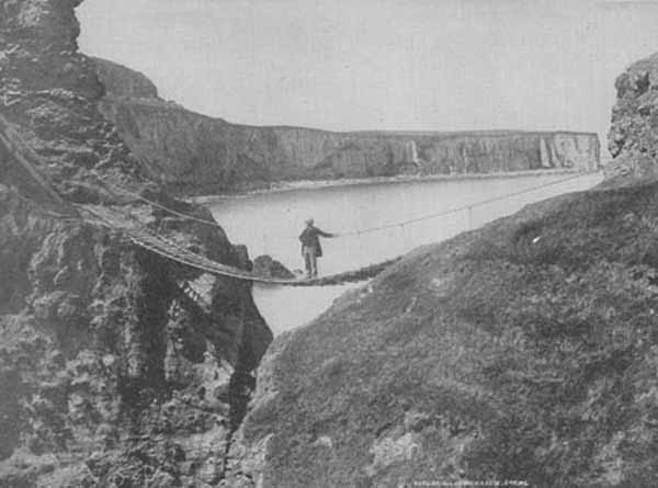
CARRICK-A-REDE. Near the village of Ballintoy, is the basaltic crag of Carrick-a-Rede—the Rock in the Road—with a flying bridge over a chasm more than eighty feet deep, connecting it with the mainland. The island is two and a half acres in extent, on which is a small cottage built as a fishing station. The bridge consists of two ropes or cables fastened to rings in the rock on either side, and a guide rope running parallel, and a boarded footpath. Over this women and children pass, carrying great loads, but to the inexperienced its crossing is a dangerous feat. The rock derives its chief interest from its being a fishing station for salmon, that annually coast along the shore in search of rivers to deposit their spawn. Their passage is intercepted by the rock, and the fish secured in the sweep of the nets. The rock is much frequented by tourists, attracted by the novelty of the feat of crossing the bridge.
Carrick-A-Rede
Description of County Antrim | Carrick-A-Rede | Antrim Round Tower | Giant's Causeway | Glenarm Castle | Dunluce Castle | Shane's Castle | Carrickfergus Castle | Portrush | Albert Memorial, Belfast | St. Patrick's Cathedral, Belfast | Antrim Map